|
Popular Birding Places |
||||||
|
|
||||||
|
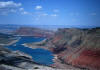
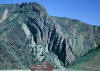
Flaming Gorge by Merrill Webb
©Merrill Webb (To print a county map along with this information, go to the Print Center) |
||||||
|
Aspen Nature Trail (also Uintah Co.) [Utah Birding Trails] eBird Data: |
Hwy 191 -- Aspen Nature Trail
| Hwy 191 -- Little Bush
Creek (Uintah Co.) | |
||||||
|
Brown's Park National Wildlife Refuge (Colorado) Directions: Go north on US 191 from Dutch John. Just after you cross the Wyoming border, turn right on Brown's Park Road (opposite "The Gap" ranch). Go 19 miles to the "Jarvie Historical Site" turn off (Jarvie Historical Site is 1/2 mile from the intersection). Proceed about 7 miles crossing the Colorado border (where the road become paved), to the wildlife refuge, about 1.5 miles from the border.. eBird Data: |
Brown's Park NWR (Colorado)
| Brown's Park WMA
| |
||||||
|
Brown's Park Wildlife Management Area [Utah Birding Trails] Directions: Go north on US 191 from Dutch John. Just after you cross the Wyoming border, turn right on Brown's Park Road (opposite "The Gap" ranch). Go 19 miles to the "Jarvie Historical Site" turn off (Jarvie Historical Site is 1/2 mile from the intersection). Proceed 0.7 miles to a small single-lane gravel road that goes down to the Wildlife Management Area. eBird Data: |
Brown's Park WMA |
Brown's Park NWR (Colorado)
| |
||||||
|
|
||||||
|
||||||
|
Henry's Fork Wildlife Viewing Area Directions: Go east from Manila on UT 43 crossing the Wyoming border where the road number changes to WY 530. Go down into the Henry's Fork River valley and cross the river where there is are parking area by the two gates. eBird Data: |
Manila |
Flaming Gorge NRA -- Henry's
Fork wetlands | |
||||||
|
Hoop Lake [Utah Birding Trails] eBird Data:
| Hoop Lake (Summit
Co.) | Birch Creek Rd -- Lower
| Spirit Lake Rd |
|
||||||
|
||||||
|
Little Hole [Utah Birding Trails] Directions: From US 191 on the north end of Dutch John, take FR75 and go east about 6 miles. Description: Pinyon-juniper woodlands (some recently burned) Birds: Lark Sparrow, Mountain Bluebird, Mourning Dove, woodpeckers.
eBird Data: |
Little Hole |
Flaming Gorge NRA -- Cart
Creek Overlook |
Little Hotel CG | |
||||||
|
|
||||||
|
||||||
|
Lucerne Valley Recreation Area Directions: Go east from Manila on UT 43 crossing the Wyoming border where the road number changes to WY 530. Go through the Henry's Fork River valley. As the road comes out of the valley turn right on the road to the Lucerne Valley Recreation Area. Go about 4 miles to the recreation area. eBird Data: |
Manila |
Flaming Gorge NRA -- Henry's
Fork wetlands | |
||||||
|
Red Canyon Overlook, Greens Lakes [Utah Birding Trails] |
||||||
|
||||||
|
|
||||||
|
||||||
|
|
||||||
|
||||||
|
|
||||||
|
||||||
|
|
||||||