|
Popular Birding Places Cache County |
|
|
|
|
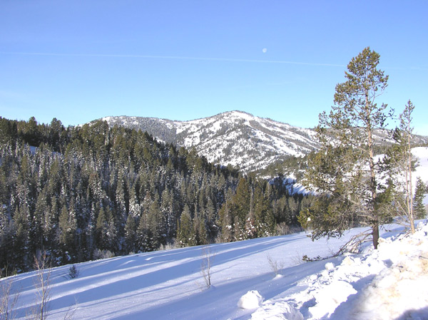
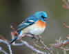
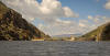
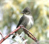
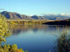
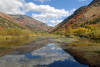
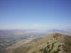
| Logan Canyon by Eric
Huish
©Eric Huish |
|
|
(To print a county map along with this information, go to the Print Center) |
|
|
|
|
| Directions: From Main Street Logan, go west on 200 North to 1000 West. Turn left and go to 600 South and turn right. Go about 1.5 miles until you cross the Logan River and immediately turn right on 2200 West. Go 1.8 miles to the ponds on the west side of the road. | |
|
|
|
 Details |
Directions: Go west from Smithfield on UT 218. Turn north
after crossing the Bear River and go about a mile on 2400 West. Turn on 7000
North which goes across the barrens. (See other directions in the "details"). |
|
Amalga-Benson Loop (24.3 miles) Details |
|
|
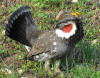
Ballard Springs (provided by Jim Lofthouse) |
|
 Details |
Directions: (1800 South Highway 165 on the East side of the highway. [south of Logan]) (See specific details coming from Logan and from Hyrum in the "details"). |
|
|
|
 Details |
Directions: From US 91 north of Logan, go west on 2500 North (Airport Road) about 2.6 miles and bear left at the intersection and go west .75 miles to a "T" in the road. Turn right and proceed the bridge across the Bear River. (There's an excellent wetlands on a trail going south along the river). Continue west another 1.75 miles to Sam Fellow Road. Turn right going north about a quarter of a mile on Sam Fellow Road to the Oxbow Overlook. |
|
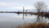
Benson Bridge & Marina GPS: N41º 47.240’, W111º 57.125’ |
|
 Details |
Directions:
Go west from Logan on Hwy. 30 (200 North) to
3200 West and turn right. Drive 3 miles to 3000 North and turn left
(west) and go 2.2 miles to the Benson Marina. (Alternate route) From US 91 north of Logan, go west on 2500 North (Airport Road) about 2.6 miles and bear left at the intersection and go west .75 miles to a "T" in the road. Turn right and proceed to the bridge across the Bear River. |
|
Canal Trail along Canyon Road |
|
 Details |
Directions: This 1-mile path begins at a drivewav on the southeast corner of 4th North and 6th East in Logan. It parallels Canyon Road past Pehrson's Floral, and is excellent warbler habitat in the spring. |
|
Cowley Walk-in Access (1000N) |
|
 Details |
Directions: Head west on 1000 N from Logan. The parking area is where this road dead-ends at about 1900 W. |
|
|
|
 Details |
Directions: From US 91 north of Logan, go west on 2500 North (Airport Road) about 2.6 miles and bear left at the intersection and go west .75 miles to a "T" in the road. Turn right and proceed to the bridge across the Bear River. |
|
|
|
 Details |
Directions: Go west from Benson to the Benson Marina and picnic area. The road turns to gravel. |
|
|
|
 Details |
Directions: Go west from Mendon on 300 North. When the road turns to gravel, continue to the parking place at the end of the road for Trailhead 39. |
|
|
|
 Details |
Directions: Denzil Stewart Park is located at 100 South 600 East in the "Island" area. If you drive east on 100 South in Logan as far as you can go, you will end at the Park. |
|
|
|
|
Details |
Directions: Ponds and marshes near the summit of Sardine Canyon on Highway 89-91. Park near the stock driveway on the south end of the valley. |
|
First Dam Reservoir (on the Logan River) |
|
 Details |
Directions: Take 400 North (Hwy. 89) in Logan, east toward Logan Canyon. On the hill before the mouth of the canyon, turn right into Canyon Entrance Park where you can park. |
|
|
|
 Details |
Directions: Take highway 89 for about 15 miles and turn left (north) on Franklin Basin Road. Continue 3.3 miles north to the site of the Soil Conservation Service Klondike Narrows Snow Survey Station. |
|
Green Canyon GPS: (approx.) N41º 46.070’, W111º 46.600’ |
|
 Details |
Directions: From Logan Main Street go east on 1800 North to 1000 East and turn left. Go one block to 1900 North and turn right going east until you reach the mouth of the canyon. There is a parking lot on your left as you pass the power station. |
|
High Creek Ridge / High Creek Canyon |
|
 Details |
Directions: Go north from Richmond on US 91 about 1 mile. Turn right at the sign to High Creek and proceed to a cattle guard. The ridge is on your left. For easiest access go another .7 miles up the road... |
|
|
|
|
Hyrum State Park, Hyrum Reservoir |
|
 Details |
Directions: From US 89/91 turn east on UT 101 going toward Hyrum. Go about 3 miles to Hyrum and approach the park from 400 West street (going south). There is a parking area near the dam (take the left fork) and one near the park headquarters (take the right fork). |
|
Left-Hand Fork Loop (17 miles) Details |
|
|
|
|
 Details |
Directions: From Logan, go north on US 91 to 2500 North and turn left. Continue about 6 blocks to the airport. (2500 North becomes Airport Rd.). |
|
Logan Mitigation Ponds (see Sue's Ponds) |
|
|
Logan River Wetlands (see Sue's Ponds) |
|
|
Mack Park GPS N41º 50.340’, W111º 49.400’ |
|
 Details |
Directions: The park is located at 50 North and 300 East in Smithfield |
|
|
|
 Details |
Directions: Go east from Logan on Highway 89 about 5 miles and turn in at Malibu-Guinavah Campground and then left into the Guinavah loop. Follow the signs to the Riverside Nature Trail, and take the 2.0 mile nature trail walk which parallels the Logan River on its south bank. |
|
McMurdy Hollow (see Meridian Road) |
|
|
Mendan Loop (17.7 miles) Details |
|
|
Meridian Road and McMurdy Hollow (submitted by Jim Lofthouse) [Paradise Loop] |
|
 Details |
Directions: From US 89/91, just northeast of Wellsville, turn east on UT 101 and go about 1 1/2 miles to 2400 West which is Meridian road. |
|
|
|
 Details |
Directions: Located near 700 North and 500 East in Logan. |
|
Sherwood Hills Resort (submitted by Kris Purdy) |
|
 Details |
Directions: From Brigham City, take US-89/91 east and north toward Logan. The resort is located at mile 12.7, west side of the road. |
|
|
|
 Details |
Directions: Take US 91 (Main Street) north out of Logan approximately 7.5 miles. In Smithfield, turn east (right) on Center Street. Drive .4 miles to the cemetery. |
|
|
|
 Details |
Directions: From Logan go west on 600 South about 4 1/2 miles out of town and you will see Spring Creek Ranch on the right (north) side of the road; a white cement gateway marks the entrance. Pull over on the shoulder after passing this gate. |
|
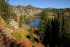
Spring Hollow (Spring, Summer & Fall) GPS: N41º 45.200’, W111º 43.010’ |
|
 Details |
Directions: Go east on US 89 (400 North) from Logan. After traveling up Logan Canyon about 4 miles to Third Dam, turn right (after mile marker 465) and cross the bridge where there is a parking loton your right. (This is the only free parking for the Spring Hollow Campground). |
|
|
|
 Details |
Directions: Go south in Mendon on UT 23 until you get to the Main Street intersection. Turn right on FR 086 and go about 3 miles to the Stewart Pass Trailhead. |
|
Sue's Ponds, (Logan Mitigation Ponds, Logan River Wetlands) |
|
 Details |
Directions: Go West out of Logan on 200N. About two miles down the road take a left on 1900W. Parking is on the right next to entry gate. If gate is unlocked, feel free to unfasten chain and enter. |
|
|
|
 Details |
Directions: Go east of Logan on 400 North (US 89) for 19.2 miles. Turn left at the Tony Grove sign (after miile marker 480) and immediately turn left again and go 7 miles to Tony Grove Lake. |
|
Tony Grove Trip (53.2 miles) Details |
|
|
|
|
 Details |
Directions: Use Deep Canyon trail, which can be found by following the dirt road extension of 3rd North in Mendon. Once on top, walk north on the west ridge about ½ mile, find a high nook to sit in, and face north for hawk watching. |
|
|
|
| Other Recommended Birding Sites | |
|
|
|