|
|
|
|
|
|
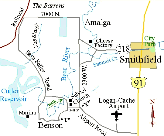
This is a half-day loop trip which takes you into typical valley habitats: marshes, reservoirs, farms and barrens. A note of warning: after a big snowfall, the road between Amalga and the railroad tracks may be impassable. Start at the James Mack Memorial Park in Smithfield (see The Amalga-Benson Loop map), which can be reached by going east from Main Street 3 blocks on 1st North and turning right (south). Travel one-half block to Canyon Road (0.0) and Mack Park. Drive west out of town on 1st North. Stop alongside the road before you cross the Bear River (2.8). The bottomlands are a good place to see Black-crowned Night Herons, Snowy Egrets, and Great Blue Herons. Continue down the highway and take a right at (3.5), the first crossroads past the turnoff to the cheese factory. Travel 0.9 miles north to Amalga and then turn left (west) on the first paved road which travels west (4.4). This turn is just past a cement silo on the right side of the road, and goes up and over an irrigation ditch right at the turn. For the next 2.8 miles you will be passing through the barrens. Stop and scan the mudflats for a variety of waders - avocets, yellowlegs, Willets, sandpipers and, Wilson's Phalarope. Turn left (south) at the railroad tracks (7.2) and continue 0.9 miles to a major crossroads (8.1). Continue south and then southeast on this road past a farmhouse until you cross a river (9.4). Park near the bridge and look for White Pelicans, Red-breasted and Common Mergansers and Buffleheads. Continue on the road until you come alongside the Bear River (11.4). Go south across the bridge (11.9) to Benson (a group of houses) at (12.6). Turn west at this intersection to the Benson Marina and picnic area at (13.7). At (12.9) the road turns to gravel. The open water on both sides of the road here (Cutler Reservoir) provides an opportunity to spot diving ducks. The picnic area is an ideal lunch spot. Retrace your steps to Benson (14.9) and on to the east skirting the Bear River. At the T intersection (15.9) turn left (north) and continue to the Benson church and school (Cache Instructional Workshop), where you will come to a stop sign at (16.7). Any place along the river here provides an opportunity for seeing a variety of waterfowl – Green-winged Teal, Gadwall, widgeon and Western Grebe. Continue north past the school and park on the right shoulder of the road at (17.1). Walk the short gravel loop which edges a rich marsh, where you should look for Yellow-headed Blackbirds and long-billed Marsh Wrens. Turn around, retrace your path to the school and church (17.4). Take a left, heading east on 3400 North. Drive 0.7 miles to the Y intersection (18.1) and turn left (north) onto 2300 West. Continue 2.3 miles on this road to (20.4) where a naked cement foundation on the right marks a right turn which skirts a large bend in the river. Take this right and drive to (21.5) where you will find the highway to Smithfield. Turn right here and return to the park in town, (24.3). |
|
|
|
|