|
Popular Birding Places
Wasatch
County
|
 |
|
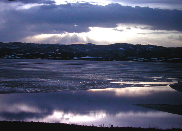
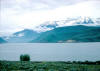
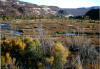
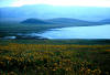
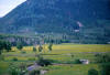
Strawberry Thaw by Merrill Webb
©Merrill Webb
|
(To print a county map along with this information,
go to the Print
Center)
|
Buck Hollow
 |
Directions: Deer Creek Reservoir lies along Hwy.
189 about 4 miles southwest of Heber or about 10 miles going east up Provo
Canyon. The road on the east end of the reservoir that goes through
Charleston to Midway is a main access road to the good birding areas when the
reservoir is full. |
| Details |
Co-op Creek Trail
 |
Directions: While traveling east on Highway 40
through Strawberry Valley turn left toward Co-op Creek just before the
state road sheds on the right side of the road. Travel north 2.2 miles
and turn left. Then drive .6 miles to the trail head. |
| Details |
Deer Creek Dam Wetlands
 |
Directions: From US 189 in Provo Canyon, turn
off to the south just below the Deer Creek Reservoir Dam. Immediately (at
the stop sign) turn left (signed "River Access") and go about 100 yards or
so to a paved road the goes off to the right. Follow this road across
the bridge and to a small parking lot with street signs "Deer Creek Parkway"
and "Little Deer Creed Rd." |
|
Details |
|
Deer Creek Reservoir
 |
Directions: Deer Creek Reservoir lies along Hwy.
189 about 4 miles southwest of Heber or about 10 miles going east up Provo
Canyon. The road on the east end of the reservoir that goes through
Charleston to Midway is a main access road to the good birding areas when the
reservoir is full. |
|
Details |
Duchesne Ridge
 |
Directions: Go to Wolf Creek
Campground which is located along US 35, 18 miles east of Francis and 16
miles west of Hannah. As you go off the main road towards the campground,
take the first road on the right. This is a fairly bumpy but passable (in
good weather) dirt
road that goes along Duchesne Ridge about 7 miles to the
Mill Hollow road. |
| Details |
|
Fields Northwest of Heber (See
Potters Lane)
|
Heber Valley Water Treatment
Facility
 |
Directions: See
Details for instruction from three
different directions. |
|
Details |
|
Jordanelle
Reservoir
 |
Directions: Jordanelle Reservoir is east of US 40 between Silver
Creek Junction and Heber. (See Rock Cliffs Recreation Area) |
|
Details |
|
Jordanelle Wetlands & Provo
River Restoration Project
 |
Directions: Exit Route 40 about 2 miles
north of Heber (below the Jordanelle Dam) at the stoplight at River Road
and proceed east on Route 32 for ~1/4 mile to Old Route 40. Then turn
north... |
|
Details |
|
Midway Fish Hatchery
(Presently closed because of "whirling disease")
Directions: Go south on Center Street (East Charlestown Road) in
Midway to 850 South and turn left. After crossing the cattle guard go
right down to the parking area.
(Weather
Forecast)
|
Mill Hollow Reservoir
 |
Directions: The turn off to Mill Hollow Reservoir is located
along US 35, 14 miles east of Francis and 20 miles west of Hanna. Go about
3 miles from the sign to Mill Hollow Reservoir on a good dirt/gravel road (it
becomes dirt/gravel after a few hundred feet). |
|
Details |
|
Potters Lane,
and the fields northwest of Heber
 |
Directions: From US 40 about 1.5 miles north of
Heber, go west on Potters Lane and begin birding. Turn left at the
first road (525 West) and go to 1800 N., birding as you go. Turn Right
(going west) and proceed to 1750 West and turn left. Go about 1/2 mile
to 1200 N. and turn left. If you go straight for about 2 miles, you'll
come out on US 40 at "The Other End" (a drinking establishment) about 1/4
mile north of Heber. (You can also make the loop in the opposite direction). |
|
Details |
|
|
|
Provo River
Restoration Project (See
Jordanelle Wetlands)
|
Rock Cliff Recreation Area
 |
Directions: Go north of Heber on US 40 about 2
miles and turn right on UT 32. Go about 6 miles and turn left into the
entrance of the recreation area. |
|
Details |
Soapstone Basin Road
 |
Directions: You can approach the Soapstone
Basin Road from the north or from the south:
From the north: Take the Mirror Lake road (State Highway 150) going
east from Kamas. Go about 16 miles and turn right (going south) at
the Soapstone turnoff. (You will pass a fee station before you get to the
Soapstone turnoff, but you don't have to stop and pay the fee because you will
be turning off the Mirror Lake road and won't be using the campgrounds or
facilities).
From the south: The turnoff is on US 35, about 15 miles east of
Francis or 16 miles west of Hanna in Duchesne Co. |
| Details |
|
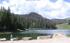
Strawberry River Valley
(Strawberry Reservoir, Soldier Creek Dam)
 |
Directions: 1. Go east from Fruitland on US 40
about 3 miles and turn right on the Red Creek Road. Go about 6.3 miles
and turn right toward Camelot Resort. Take the right fork toward the
Strawberry River. This is the view road for the Strawberry River
Valley.
2. Go west from Duchesne on US 40. After passing Starvation
Reservoir, go 3 miles and turn left on 29520 West. When you see the sign
for Camelot Resort, turn left to the resort. Take the right fork toward
the Strawberry River. This is the view road for the Strawberry River
Valley. |
|
Details |
Wallsburg
 |
Directions: Wolf Creek Campground is located
along US 35, 18 miles east of Francis and 16 miles west of Hanna. |
| Details |
Wasatch Mountain
State Park
 |
Directions: Go west on Main St. in
Midway to 200 West (stop sign) and turn right onto SR 272 which turns left
on 200 North and right onto 700 West or Homestead Dr. Go about 1.3
miles passing the Homestead and Zermatt Resorts and curving left to come to the Wasatch Mountain State Park
Visitor Center. |
| Details |
Wolf Creek Campground
 |
Directions: Wolf Creek Campground is located
along US 35, 18 miles east of Francis and 16 miles west of Hanna. |
| Details |
Woodland (Summit
County)
 |
Directions: From Francis, go east on UT 35
about 5 miles to the small town of Woodland along the Provo River. |
| Details |
|
|
|

|
| |
| |
|
|
| |
|
|