|
Popular Birding Places Uintah County |
||||
 |
||||
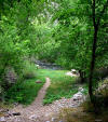
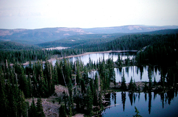
| Uinta Mountains, looking
south from Notch Mountain by Merrill Webb
©Merrill Webb |
||||
| (To print a county map along with this information, go to the Print Center) | ||||
|
Ashley Creek in Vernal Description: There are several different places where birders can get close to the cottonwoods and scrub vegetation along the creek. None of these access points is a real big area - it's mostly "spot" birding rather than taking a walk. Directions: (Three access points, all in Vernal) Some birds you might see: Black-headed Grosbeaks, Cedar Waxwings, Bullock's Orioles, Yellow Warblers, Spotted Towhees, Lazuli Buntings, Song Sparrows, and Gray Catbirds. (Information provided by "Cynwren") eBird Data: |
Remember the Maine Park |
McConkie Ranch Rd |
Stensgard's Pond |
|
||||
|
Dinosaur National Monument [Utah Birding Trails] eBird Data: |
Dinosaur National Monument
(Colorado) | |
||||
|
Aspen Nature Trail [Utah Birding Trails] eBird Data: |
Hwy 191 -- Aspen Nature Trail
| Hwy 191 -- Little Bush
Creek | |
||||
|
Dry Fork Trail, Flume Trail (lowland riparian forest) [Utah Birding Trails] Directions: Go west on 500 North Street (UT 121) in Vernal to 3500 West Street and turn north. This road leads to Dry Fork Canyon. Comments: Dry Fork Trail - I call it that because it parallels Dry Fork Creek - but it's called the Flume Trail on all the signs because it leads to an historic flume site several miles past the Forest Service boundary. It's a nice hike and gets into fairly thick coniferous forest further up. Blue and ruffed grouse can be seen on some of the upper parts of the trail. The lower part is probably the best overall birding though, since it has the most diverse vegetation and more riparian influence due to some springs in the area. (Kathy Paulin) Birds: Mourning dove, White-throated swift, Broad-tailed hummingbird,
Hammond's flycatcher, Cordilleran flycatcher, Plumbeous vireo. Warbling vireo,
Mountain chickadee, Red-breasted nuthatch, Canyon wren, Swainson's thrush,
American robin, Cedar waxwing, Yellow warbler, Yellow-breasted chat,
Green-tailed towhee, Black-headed grosbeak |
||||
|
Directions: From UT 40 (about 14 miles SW of Vernal), go south on the road leading to Ouray (UT 88). After about 8 miles, turn right on the road to Randlett. Go less than 3 miles and turn left on the Pelican Lake turnoff. Go about 2 miles to where the road takes a sharp turn to the left. The pond is on the right side of the road. eBird Data: | |
||||
|
Flume Trail (see Dry Fork Trail) eBird Data: |
Flume Trail | |
||||
|
Directions: Go north of Jensen on UT 149 about 7 miles to the west entrance of Dinosaur Nation Monument. The Green River Campground is about 4 miles from the entrance station. (The path going north to Split Mt. Campground is good for birding) eBird Data: |
Green River CG | |
||||
|
Location: 1800 E. 5000 S. in the Davis area of Ashley Valley [near Naples]. eBird Data: |
Stensgard's Pond | |
||||
|
|
||||
|
||||
|
Josie Morris Cabin [Utah Birding Trails] eBird Data: |
Josie Morris Cabin |
|
||||
|
|
||||
|
||||
|
Montes Creek Reservoir [Utah Birding Trails] Directions: Go about 2 miles east of Roosevelt on US 40. Turn north on Montes Creek Road and go about 3 miles to the reservoir. (Montes Hollow in on the west end of the reservoir and Lynn Haslem Reservoir is on the east end). eBird Data: |
Little Montes Creek WMA
| Bullock Reservoir |
Cottonwood Reservoir | |
||||
|
|
||||
|
||||
|
Oxbow Pond [Utah Birding Trails] Directions: The oxbow pond just South of the Green River bridge on the
new Bonanza highway (UT 45). Just across the bridge you'll find a gravel pit on
the right (west) side of the road -- the pond is on the far side of the pit. Access is good most of the year. (Michael Weber) eBird Data: |
SR45 & Green River Oxbow Pond
| |
||||
|
Pariette Wetlands [Utah Birding Trails] eBird Data: |
Pariette Reservoir & Wetlands
| |
||||
|
|
||||
|
||||
|
Red Cloud Loop [Utah Birding Trails] eBird Data: |
Dry Fork / Red Cloud Loop |
Taylor Mountain Road |
Oak Park Reservoir | |
||||
|
Directions: Take 2500 West north out of Vernal. It becomes the Taylor
Mtn. Road. The 2-track leading off it is maybe 0.5 mile past the Forest
boundary. (Kathy Paulin) Comments: Right now [fall], the trees are full of nuthatches (both red and white breasted). They're at least as numerous and easy to see as the mountain chickadees, maybe even more so. It would be a good spring hike too, since in the breeding season, mature ponderosa pine stands are one of the most productive forest types around for song birds - second only to riparian areas for total number of species (based on some point count surveys the Forest Service has done around here). (Michael Weber) Rojo Trail: This is on the SW flank of Red Mountain just north of
Vernal. Habitat is PJ, sage and mountain brush at the lower end with some
ponderosa pine as you go higher. The trail follows a (usually) dry wash with
potholes and occasional pockets of riparian vegetation for about a mile before
branching off to an overlook point. (Kathy Paulin) eBird Data: |
Taylor Mountain Road | |
||||
|
Directions: Go north on US 191 (Vernal Avenue) to Maeser Highway (500 North) and turn left. Go 4 miles to 3500 West and turn right following the signs to Dry Fork Canyon. Go 3.7 miles to the park on the right side of the road. Comments: Peregrines sometimes nest on the cliff face above the park. (Kathy Paulin) eBird Data: |
Remember the Maine Park |
McConkie Ranch Rd |
Stensgard's Pond | |
||||
|
Directions: Go north of Jensen on UT 149 about 7 miles to the west entrance of Dinosaur Nation Monument. The Split Mountain Campground is about 2.5 miles from the entrance station. (The path going south to Green River Campground is good for birding) eBird Data: |
Split Mountain Gorge |
|
||||
|
Steinaker Reservoir - north end [Utah Birding Trails] This stand of cottonwoods isn't very big but it can be productive. (Kathy Paulin) Directions: The reservoir is located a few miles north of Vernal on SR 121. (Don DeCamp) Description: Park Officials have added a raised walkway that extends approximately 200 yards through various stands of riparian and wetland habitats. The place is very well maintained and the source of a multitude of bird sightings. (Don DeCamp) Comments: eBird Data: |
Steinaker SP |
|
||||
|
Stewart Lake WMA [Utah Birding Trails] eBird Data: |
Stewart Lake WMA |
Jensen Bridge | |
||||
|
Taylor Mountain Road [Utah Birding Trails] eBird Data: |
Taylor Mountain Road |
Dry Fork / Red Cloud Loop |
Oak Park Reservoir | |
||||
|
|
||||
|
|