Popular Birding Places
Duchesne County

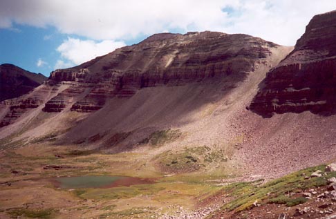
Anderson Pass    by Tim Gorman    ©Tim Gorman


Duchesne Waste Treatment Plant  (Sewage Lagoons)


Indian Canyon (in Duchesne and Carbon Counties)

Directions: About 3 miles north of Helper on Hwy. 6, take Hwy. 191 which heads in a generally northeast direction to Duchesne.

 Details


Lake Boreham  (Midview Reservoir)


Mallard Springs   [Utah Birding Trails]

     eBird Data:   |  West Duchesne River PondDuchesne River PondsEast Duchesne River Pond |


Midview Reservoir (Lake Boreham)  [Utah Birding Trails]

Directions: Go east of Duchesne about 12 mile (or west of Myton about 12 miles) on US 40 and turn northwest and  go about a mile to Bridgeland.  From Bridgeland go northeast about a 1 1/2 miles to a set of forks in the road.  Keep right on the first to forks then turn right on a road going east.  Go about 2 miles to the reservoir. 

Details


Mirror Lake  (Best accessed through Summit County)


Sewage Lagoons,  (Duchesne Waste Treatment Plant)

Directions: The sewage lagoons are located on the north side of US 40 on the east edge of the town of Duchesne.

Details


Starvation Reservoir

Directions: To East Side:  On US 40, go to the west end of the town of Duchesne.  Take Road 311 and go about 3 miles heading northwest to the Starvation State Park.
To the West End:  Go 18 miles east of Fruitland or 10 miles west of Duchesne on US 40 and turn south on Strawberry River Road to the west end of the reservoir.  (The road continues to the west along the river and then turns north to come out on US 40 about 3 miles east of Fruitland).

Details


Strawberry River WMA [Utah Birding Trails]

     eBird Data:   |  Strawberry Pinnacles |


Upper Duchesne River

Directions:  The Upper Duchesne River drainage can be accessed from Wolf Creek Pass, from Mirror Lake, or via Murdock Basin and Little Deer Creek, also near the Mirror Lake Highway.

Details


From Wolf Creek Pass   by Marlene Foard    ©Marlene Foard


Return to the Utah Birds Home Page