|
Merrill Webb's |
||||||||
|
Page 3 of 3 |
||||||||
|
(Listed Alphabetically)
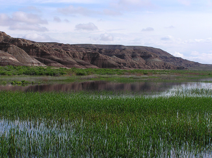
Pelican Lake and Ouray National Wildlife Refuge (Uintah County)
Since these two locations are in close proximity to each other in Uintah County, both can be accessed in one day. Neither location is especially scenic, but both are productive places to look for birds, especially in the spring and early summer. In the Uintah Basin (eastern Utah) drive east from Roosevelt on US Highway 40 to junction with Highway 88 and then turn right (south). Pelican Lake is about eight miles on the right. This lake provides good habitat for warm water fish (bluegill and green sunfish), and of course, food for birds that like eating those fish. Watch for Double-crested Cormorants, Great Blue Heron, four species of grebe, and mergansers (during migration). Also, watch for Cinnamon Teal, Green-winged Teal, Redhead, Ring-necked Duck, Lesser Scaup, Bufflehead, and Ruddy Duck. Continue south on Highway 88. Less than ten miles there is a turn-off on the left to Ouray National Wildlife Refuge. There is no charge, but it is always good to check in at the refuge headquarters to inquire about road conditions and recent bird sightings. There are many units to check out, but some are closed to the general public. The roads around the open units are among some of the best places in Utah to observe the American Bittern, Lewis’s Woodpecker and Eastern Kingbird. Watch also, for Sora, Virginia Rail and, during migration, assorted shorebirds. Pine Valley (Washington County) The town of Pine Valley is approximately 32 miles north of St. George in southwestern Utah. At the north end of Bluff Street in St. George there is a junction to either Santa Clara (left), or straight ahead (north) to Enterprise on State Highway #18. Take this road (#18) and drive past Snow Canyon State Park, through Damaron Valley, and Veyo to Central. At the town of Central turn right (east) and drive about seven miles to the picturesque town of Pine Valley, nestled at the foot of the ponderosa pine-covered Pine Valley Mountains. At the junction where the white church is (on the right) turn left and drive east toward the canyon where there is a small lake and numerous camping sites. During the summer months there is an entrance fee since it is managed by the Dixie National Forest. This is a great place to look for birds, especially during the winter when there isn’t a lot of traffic and people. Snow shoes are useful, but not required. As you walk along the road that leads to the campgrounds watch for Wild Turkey, Band-tailed Pigeon, Hairy Woodpecker, Steller’s Jay, White-breasted and Pygmy Nuthatch, Red Crossbill and Cassin’s Finch. During the summer watch for Grace’s Warbler and Mountain Bluebirds. There isn’t a through road from Pine Valley so you have to return to Central. If you turn right at the junction and drive toward Enterprise you will come to the Mountain Meadow Massacre Monument site. I have found Black-chinned Sparrows here. Sheep Creek Canyon (Utah County)
This is one of the routes where a Uinta National Forest road map would be most useful. Drive east through Spanish Fork Canyon on US Highway 6 about twenty miles from the I-15 exit. There will be a small road sign indicating Sheep Creek Canyon turnoff to the north (left). It is about 25 miles from this junction to Strawberry Reservoir in Wasatch County. The roads are pretty good, but are not open during the winter. I have done one of my Breeding Bird Surveys on this route for more than fifteen years, and there are at least four, distinct plant community types with associated elevation increase that provide habitat for 40-45 species of birds. The lower elevation is characterized by scattered juniper trees. Watch for Western Kingbird, Common Nighthawk, Mountain Bluebird, and Blue-gray Gnatcatcher. A couple more miles up the road and the habitat becomes a mixture of pinion-juniper and oak-maple that provides habitat for Virginia’s and Black-throated Gray Warblers as well as Ash-throated Flycatcher and Plumbeous Vireo. Drive another couple of miles and Great Basin Sagebrush, mingled with oak, becomes the dominant vegetation type with Green-tailed Towhee, Vesper and Brewer’s Sparrows. After another couple of miles the road drops in elevation and curves to the north. A small wet meadow with aspens to the east and oak brush to the left of the road hosts anywhere from ten-fifteen species at this one spot, so watch for House Wren, Black-headed Grosbeak, Red-naped Sapsucker, Yellow Warbler and Lazuli Bunting. After about another mile there is a road junction. Turn right (south) onto a gravel road. This road goes to Strawberry Reservoir. If you were to go on straight the road would eventually take you down to Springville Crossing and into Diamond Fork Canyon, one of the places I mentioned earlier. At any rate, this road climbs higher in elevation, goes along a saddle providing great views down into Spanish Fork Canyon on one side and aspen covered slopes on the other. MacGillivray’s Warbler is common in this stretch (on the aspen side) as well as woodpeckers, juncos and kinglets. A little farther along I have found Red-breasted Nuthatches, Clark’s Nutcrackers and Townsend’s Solitaire. Eventually, the road forks. Take the left fork which is the road to Indian Creek. This goes through beautiful aspen forests before opening up into sagebrush flats and then finally into Strawberry Valley where the reservoir is located. Northern Goshawk has been sighted a couple of times along this Indian Creek road, so check out each raptor. Mountain Bluebirds are common as well. A word of caution: the Indian Creek road was closed due to some construction work last summer, and at this time (mid-January) I do not know the status of the road. Check with the Spanish Fork Ranger District office before attempting to go all the way through. Soapstone Basin (Wasatch County)
To access the road to Soapstone Basin travel east from the town of Kamas (Summit County) on the Mirror Lake highway (#150). After about half an hour watch for a large pull-out area with some information signs. This is the road that goes south into the basin. This road is another one of my Breeding Bird Survey routes, and regularly produces a variety of high elevation species as well as some interesting riparian species. As the Provo River is crossed watch for the American Dipper and listen for Swainson’s Thrush. This is a fairly good gravel road, but is not open to through traffic during the winter. During the summer the high mountain meadows are full of wild flowers making the basin one of the most beautiful areas in the state to drive through. Birds along the route are Broad-tailed Hummingbirds, Pine Siskin, Olive-sided Flycatcher, Mountain Bluebird, Red Crossbill, Vesper Sparrow, Fox Sparrow, Lazuli Bunting, Western Wood-Pewee, Hermit Thrush, Green-tailed Towhee, and Macgillivray’s Warbler. Once you leave the basin and drive south towards the Wolf Creek highway the road goes through aspen and then spruce forests. Watch for Red-breasted Nuthatch, Red Crossbills, Pine Grosbeaks and American Three-toed Woodpeckers. When you reach the junction the road is paved. Turning left will take you to Wolf Creek Campground, another good place for the three-toed woodpecker. Turning right will take you down to Woodland, Francis, and then back to Heber City. Either way the road passes through beautiful spruce-fir forest with a nice mix of aspen. South Willow Canyon (Tooele County)
Probably the easiest way to access this canyon is to travel to the west side of the town of Grantsville in Tooele County and then take the road south toward Saint John. You will travel through Gt. Basin Sagebrush for about ten miles (watch for Long-billed Curlew) and then take the road to the right (west) that goes to South Willow Canyon. The mountain range to the west is called the Stansbury Mountains. These are the beginning of what is called the “basin and range” province that extends westward across the Great Basin Desert to Reno, Nevada. These “island” mountains with associated vegetation provide habitat for an interesting variety of birds. The Stansburys are especially attractive to fall migrants, and some interesting warblers have been recorded in South Willow Canyon including Nashville, Townsend’s, Black-throated Blue, Tennessee and Ovenbird . Summer residents include Hammond’s Flycatcher, Western Scrub Jay, Townsend’s Solitaire, Hermit Thrush, American Dipper (stream), Western Tanager, Mountain Chickadee, Red-breasted Nuthatch, Brown Creeper, and Clark’s Nutcracker (higher elevation along the trail). The campgrounds at higher elevations are administrated by the Wasatch National Forest so there is a nominal user fee.
This completes my top twenty. If I were naming 25 I would have added
the area around Brighton,
the Raft River Mountains, Flaming
Gorge Reservoir area, the
Skyline Drive east
of Fairview and the Alpine Loop on
the slope of Mt. Timpanogos. But, enough is enough. By visiting the
twenty locations I have mentioned the observer would be able to list
somewhere between 250 and 275 species in Utah. By visiting these places
regularly during the last 27 years I have averaged 275 species. So it
is doable. |
||||||||
|
| Back to Page 1 | Back to Page 2 | |