|
Popular Birding Places |
|
 |
|
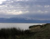
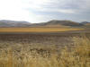
| North Slope of the Raft River Mountains by Merrill Webb
©Merrill Webb |
|
|
(To print a county map along with this information, go to the Print Center) |
|
|
|
|
|
Bear River Migratory Bird Refuge (web site) |
|
|
|
Directions: From Interstate 15 at Brigham City, take exit #363
(Forest Street) and turn west. Go 13 miles to the beginning of the Auto Tour
Route. - From U.S. Highway 89 in Brigham City, follow Main Street to Forest Street (downtown) and turn west, taking Forest Street all the way to the Refuge. |
|
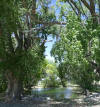
Box Elder Campground (submitted by Kris Purdy) Description: Box Elder Campground is located in the riparian corridor of Box Elder Creek on the east side of Mantua. The stream banks are thickly lined with dogwood and other shrubs and trees include Box Elders, cottonwoods, and willows.. Directions: From Brigham City, take US-89/91 east. In 1 1/2-2 miles, take the first Mantua Exit, then the first right onto 300W and follow the signs to the campground. From Logan, travel south on US-89/91. Take the first Mantua exit, then turn right into town on Main Street. Follow Main to the stop sign and turn right on Box Elder Park Road. Birds: Great Horned Owls,
Winter Wrens (in winter)
Ruby-crowned Kinglets, Cedar
Waxwings, Northern Flickers,
Downy Woodpeckers, Red-naped Sapsuckers, chickadees,
Ruffed Grouse,
Red-tailed Hawk eBird Data: |
Box Elder CG |
Mantua Reservoir | |
|
|
Clear Creek |
|
|
|
Directions: Go west from Snowville on UT 42 to Strevell, (an old town site) just across the Idaho border. Go west on the gravel road 3.3 miles to the Clear Creek Campground sign. The campground is south and west of the sign 6.2 miles. |
|
Dale Young Nature Park (Perry Nature Park) Directions: Take I-15 north and exit at the Brigham City 1100th south exit (#362). Go east to Main Street, turn right, (going south) you are now on US Highway 89. Go past Maddox Ranch House and turn right (west) at 2250 South. Go 3-4 blocks west and you are there. ~ Sharon Andrus eBird Data: | Perry Nature Park | I-15 -- Exit 362 (Flying J & Vicinity) | Bear River MBR -- Visitor Center | Maps: Perry
City |
|
|
Devil's Playground Directions: eBird Data: |
Keg Spring (to the
NW) | |
|
|
Golden Spike National Historic Site Directions: Take Exit 365 off I-15 near Brigham City and go about 20 west on UT 83. Turn left and go about 8 miles, follow the signs to Golden Spike NHS. Description: Grasslands and desert shrub with rocky outcroppings. You can take the auto tour or walk along the 1.5 mile "Big Fill" trail. Specialty Birds: Sharp-tailed Grouse, Ferruginous Hawk,
Barn Owl, Sage Thrasher
and Brewer's Sparrow eBird Data: |
Golden Spike |
Golden Spike -- Big Fill | |
|
|
Grouse Creek Mountains Directions: This area is north of Lucin. (Good directions for access to this area are requested). eBird Data: | Keg Spring (to the NE of Grouse Creek Jct.) | |
|
|
Directions: Go south then west of Yost for 1 mile until you get to a sign for Johnson Creek. eBird Data: |
Raft River Mtns --
Johnson Creek | |
|
|
Locomotive Springs Wildlife Management Area Directions: Go about a mile northeast from Golden Spike NHS (see above), to UT 504, follow the signs west about 22 miles then turn left and go about a mile to Locomotive Springs. eBird Data: |
Locomotive Springs WMA
| |
|
|
|
|
|
Lucin ( Checklist ) |
|
|
|
|
|
|
|
|
Mantua Reservoir |
|
|
|
|
|
|
|
|
Mayor's Pond |
|
|
|
|
|
|
|
|
Raymond M. Hansen Park (Elwood, Utah) Description: Hansen Park is located in the town of Elwood, Box Elder County, southeast of Tremonton. The park sits on a curve of the Bear River and offers old-growth deciduous woods, open fields and brushy edges. Directions: Take I-15 to Exit 376 and turn north. Just after the red-roofed Exxon/Arby's Travel Center, turn right (east) on 9600N. The intersection might not have a street sign, but there's a sign for a health food store in the direction you should turn. Drive east for a mile and turn right (south) onto 4400W. at the four-way stop. Drive south a half mile and turn right (west) onto River Road. The park entrance is a couple hundred feet down River Road on the left. Birds: Lazuli Bunting, Black-headed Grosbeak, Bullock's Oriole, Yellow Warbler, Blue-gray Gnatcatcher, Ring-necked Pheasant, Black-capped Chickadee, Bank Swallow, Belted Kingfisher, American Goldfinch, Cedar Waxwing. Other: The park is closed in the winter, however, if you continue down River Road past the entrance you can look down into the park along a hillside covered with Russian Olives. You'll also get a view of the river from this vantage point and you may see waterfowl if the water is open. eBird Data: | Petersen Park | Submitted by Kristin Purdy |
|
|
Description: The Promontory Mountain Range separates the
north end of Great Salt Lake into Bear River Bay to the east and Gilbert Bay to
the west. Promontory Road runs 21 miles down the east base of the mountains
through sagebrush and grasslands, and farm and range. Submitted by Kristin Purdy - 16 May 2012 eBird Data: |
Promontory Rd -- 6.5 mile Pond
| Promontory Rd | |
|
|
Salt Creek WMA, Compton's Knoll Directions: Take I-15 north to Exit # 365 (900 N. St.). Turn
RIGHT onto Hwy. 13 North. Go 6.2 miles west on Highway 83 (taking the LEFT fork
at Corinne). SHORTCUT from Bear River's Wildlife Education Center Specialty Birds: Northern Harrier, Cinnamon Teal and Sandhill Crane (winter) Bald Eagle eBird Data: | Salt Creek WMA | |
Trip Report: Wasatch
Audubon | Map (PDF) | |
|
|
Salt Hills Flat / Salt Wells Flat WHA Directions: From the road about 1 mile north of Promontory, go west about 12 miles. eBird Data: |
Salt Wells Flat WHA | |
|
|
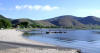
West of Willard Reservoir (submitted by Kris Purdy) Description: Great Salt Lake's Willard Bay and the
manmade Willard Reservoir meet along Willard Reservoir's west dike. Due to the
proximity of the freshwater Willard Reservoir outlet, the lakewater is very
fresh here and supports fish which attracts fish-eating birds. eBird Data: |
Willard Bay SP |
NW Playas | |
|
|
|
|
|
Whites Valley |
|
|
|
|
|
|
|
| Willard Bay State Park |
|
 Directions: Take Exit 357 about 5 miles south of Brigham City and go
west. Immediately turn left into the park. Directions: Take Exit 357 about 5 miles south of Brigham City and go
west. Immediately turn left into the park. |
|
| Details | |
|
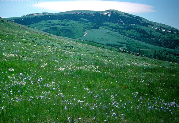
Willard Peak Road The lowland deciduous forest gives way to coniferous forest at higher
elevations, and which gives way to alpine wildflower meadows near the top of the
road. Some of the south facing hillsides at mid-level elevations support a
mahogany forest. Specialty bird at approximately 7500 feet elevation is Common
Poorwill. ~ Joseph eBird Data: |
Willard |
Ben Lomond Peak & Willard
Basin (Weber Co.) | Willard
Canyon | |
|
|
|
|