 |
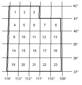
Latilongs 1, 4, 9, 14 and 19 are extended
on their western edge to the Nevada State line while latilongs 8, 13, 18
and 23 are shortened on their eastern edge along the Colorado border, the
width of the strip of land gained or lost being just over 2 miles wide.
The average dimension of each latilong is 55 miles wide and 70 miles long,
representing an average area of 3,850 square miles. Latilongs along the
Idaho border are 5.2 percent smaller than those along the Arizona border.
New maps often have special markings to assist in determining where the
longitude or lattitude lines are. However it is often difficult to place
oneself accurately on the map, especially when driving back roads. You may
wish to purchase one of the newer GPS units which are quite accurate
(within 30 feet) and are becoming fairly inexpensive, around $100.
|